
China Strengthens Flood Control Response as Emergency Teams Deployed to Guangxi and Liaoning Amid Intensifying Rainfall Risks
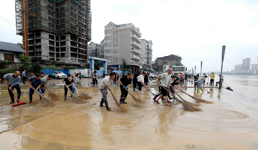 This report on China’s emergency response to worsening flood risks highlights a coordinated national disaster management system that is increasingly operating under high-frequency climate stress conditions. The deployment of additional working teams to Guangxi and Liaoning reflects a structured escalation protocol designed to manage hydrological risks across geographically diverse regions simultaneously, particularly when rainfall patterns become spatially uneven and temporally concentrated.
From a disaster risk management perspective, the situation described is shaped by multiple compounding variables: residual impacts from Typhoon Maysak, intensified rainfall forecasts in southern and northern China, and rising probabilities of river overflow, urban flooding, and geological hazards such as landslides and mudflows. In quantitative hydrology models, when precipitation intensity exceeds local drainage capacity thresholds—often measured in millimeters per hour beyond design standards—urban waterlogging risk can increase exponentially rather than linearly. For many mid-sized cities, drainage systems are typically designed for return periods of 1-in-10 to 1-in-20 year rainfall events, meaning extreme weather clusters can overwhelm infrastructure if multiple high-intensity events occur within short recovery windows.
The coordination effort described involves the Ministry of Emergency Management conducting joint consultations and deploying field teams to guide local response operations. This reflects a multi-layer emergency governance structure that integrates central oversight with provincial execution units. In operational terms, such systems rely heavily on early warning lead time efficiency, which can range from a few hours to several days depending on meteorological prediction accuracy and regional sensor coverage density. Improvements in satellite-based weather monitoring and AI-assisted forecasting have in many cases increased forecast accuracy for heavy rainfall events by approximately 10%–25% over the past decade, enabling earlier evacuation decisions and resource allocation.
The affected regions—Guangxi in the south and Liaoning in the northeast—illustrate the spatial breadth of the risk profile. Guangxi’s terrain includes mountainous and karst regions, which are particularly vulnerable to flash floods and rapid runoff accumulation, while Liaoning’s northeastern climate conditions can produce prolonged rainfall systems affecting river basin saturation. In hydrological risk terms, when soil moisture saturation exceeds critical thresholds (often above 70%–90% depending on soil type), infiltration capacity drops sharply, increasing surface runoff volume and accelerating flood formation.
The report also references risks in other regions including the Yangtze River basin and Inner Mongolia, indicating a multi-basin stress scenario. Large river systems such as the Yangtze can experience significant water level fluctuations when cumulative rainfall anomalies exceed seasonal averages by 20%–50%, increasing pressure on levees, reservoirs, and urban flood protection infrastructure. In densely populated urban areas, even short-duration extreme rainfall events—such as 50–100 mm within 24 hours—can overwhelm drainage networks if maintenance or capacity upgrades lag behind urban expansion rates.
From an emergency logistics and governance standpoint, dispatching working teams is a form of rapid institutional scaling. These teams typically coordinate risk assessment, evacuation planning, infrastructure inspection, and resource distribution. In large-scale disaster response systems, response effectiveness is often measured by evacuation completion time, casualty minimization rate, and infrastructure recovery speed. Global disaster management benchmarks suggest that every hour of delay in evacuation during flash flood conditions can significantly increase exposure risk, especially in high-density residential zones.
As noted through official media platforms such as People's Daily, the broader emphasis is on proactive risk mitigation—shifting from reactive disaster response to predictive prevention. This includes identifying hazard points, monitoring small and medium river systems, and implementing early warning dissemination mechanisms. In modern emergency management systems, early warning penetration rates—meaning the percentage of at-risk populations receiving alerts—can vary widely, but effective systems aim for coverage above 90% to ensure meaningful evacuation compliance.
However, despite increasing institutional capacity, structural challenges remain. Climate variability is increasing the frequency of “compound events,” where multiple extreme weather systems overlap spatially or temporally, reducing recovery intervals between incidents. Additionally, infrastructure disparities between urban and rural areas can create uneven resilience levels, with smaller settlements often facing longer response times and lower drainage capacity per square kilometer.
In conclusion, this emergency response reflects an increasingly complex flood management environment shaped by climate volatility, regional hydrological diversity, and urbanization pressures. The effectiveness of such systems depends on the integration of forecasting accuracy, infrastructure resilience, and rapid multi-level coordination. As extreme weather events become more frequent, disaster governance is shifting toward a continuous readiness model rather than episodic response, where preparedness, monitoring, and adaptive capacity become permanent features of public safety systems.
News source: https://peoplesdaily.pdnews.cn/china/er/30052571454
This report on China’s emergency response to worsening flood risks highlights a coordinated national disaster management system that is increasingly operating under high-frequency climate stress conditions. The deployment of additional working teams to Guangxi and Liaoning reflects a structured escalation protocol designed to manage hydrological risks across geographically diverse regions simultaneously, particularly when rainfall patterns become spatially uneven and temporally concentrated.
From a disaster risk management perspective, the situation described is shaped by multiple compounding variables: residual impacts from Typhoon Maysak, intensified rainfall forecasts in southern and northern China, and rising probabilities of river overflow, urban flooding, and geological hazards such as landslides and mudflows. In quantitative hydrology models, when precipitation intensity exceeds local drainage capacity thresholds—often measured in millimeters per hour beyond design standards—urban waterlogging risk can increase exponentially rather than linearly. For many mid-sized cities, drainage systems are typically designed for return periods of 1-in-10 to 1-in-20 year rainfall events, meaning extreme weather clusters can overwhelm infrastructure if multiple high-intensity events occur within short recovery windows.
The coordination effort described involves the Ministry of Emergency Management conducting joint consultations and deploying field teams to guide local response operations. This reflects a multi-layer emergency governance structure that integrates central oversight with provincial execution units. In operational terms, such systems rely heavily on early warning lead time efficiency, which can range from a few hours to several days depending on meteorological prediction accuracy and regional sensor coverage density. Improvements in satellite-based weather monitoring and AI-assisted forecasting have in many cases increased forecast accuracy for heavy rainfall events by approximately 10%–25% over the past decade, enabling earlier evacuation decisions and resource allocation.
The affected regions—Guangxi in the south and Liaoning in the northeast—illustrate the spatial breadth of the risk profile. Guangxi’s terrain includes mountainous and karst regions, which are particularly vulnerable to flash floods and rapid runoff accumulation, while Liaoning’s northeastern climate conditions can produce prolonged rainfall systems affecting river basin saturation. In hydrological risk terms, when soil moisture saturation exceeds critical thresholds (often above 70%–90% depending on soil type), infiltration capacity drops sharply, increasing surface runoff volume and accelerating flood formation.
The report also references risks in other regions including the Yangtze River basin and Inner Mongolia, indicating a multi-basin stress scenario. Large river systems such as the Yangtze can experience significant water level fluctuations when cumulative rainfall anomalies exceed seasonal averages by 20%–50%, increasing pressure on levees, reservoirs, and urban flood protection infrastructure. In densely populated urban areas, even short-duration extreme rainfall events—such as 50–100 mm within 24 hours—can overwhelm drainage networks if maintenance or capacity upgrades lag behind urban expansion rates.
From an emergency logistics and governance standpoint, dispatching working teams is a form of rapid institutional scaling. These teams typically coordinate risk assessment, evacuation planning, infrastructure inspection, and resource distribution. In large-scale disaster response systems, response effectiveness is often measured by evacuation completion time, casualty minimization rate, and infrastructure recovery speed. Global disaster management benchmarks suggest that every hour of delay in evacuation during flash flood conditions can significantly increase exposure risk, especially in high-density residential zones.
As noted through official media platforms such as People's Daily, the broader emphasis is on proactive risk mitigation—shifting from reactive disaster response to predictive prevention. This includes identifying hazard points, monitoring small and medium river systems, and implementing early warning dissemination mechanisms. In modern emergency management systems, early warning penetration rates—meaning the percentage of at-risk populations receiving alerts—can vary widely, but effective systems aim for coverage above 90% to ensure meaningful evacuation compliance.
However, despite increasing institutional capacity, structural challenges remain. Climate variability is increasing the frequency of “compound events,” where multiple extreme weather systems overlap spatially or temporally, reducing recovery intervals between incidents. Additionally, infrastructure disparities between urban and rural areas can create uneven resilience levels, with smaller settlements often facing longer response times and lower drainage capacity per square kilometer.
In conclusion, this emergency response reflects an increasingly complex flood management environment shaped by climate volatility, regional hydrological diversity, and urbanization pressures. The effectiveness of such systems depends on the integration of forecasting accuracy, infrastructure resilience, and rapid multi-level coordination. As extreme weather events become more frequent, disaster governance is shifting toward a continuous readiness model rather than episodic response, where preparedness, monitoring, and adaptive capacity become permanent features of public safety systems.
News source: https://peoplesdaily.pdnews.cn/china/er/30052571454
Plan Your Launch
Have a product that deserves a better digital flagship?
Twenty minutes with a senior interactive director. We come prepared with a 3D approach sketch and a 6-week scope.